
It’s a habit, almost a ritual. On Boxing day we go on a beach walk, blow away the cobwebs, usually at Happisburgh. This drives further back than our family now. We did the same when I was a child. My mum and dad and whoever else happened to be there on Boxing Day were all thrust into the bench seat of our Morris Traveler, someone’s lap the seat for the trembling terrier, eyes wide at the thought of the freedom, smells and sand. If there were too many children the boot space was used facing back like arse-end Charlies in some old wooden-framed aircraft dodging and riding low on creaking leaf-springs as it bumped and scuffed along the winding enclosed side-roads; White Horse Common, Meeting House Hill, Ebridge, Witton, Ridlington and finally on to Happisburgh.
The car park was then a small rutted field not far from the caravan park, the Manor house still stands nearby and the tall rich church beside you. And in front the sea. There was a ramp, a putty grey stone chipped concrete tongue stretching out at the end of the road into the solid wood and metal of the defences the tip tasting the sand or the salt tide. Heavy slatted wood sectioned the beach into two strips; the sea and the sand on one side and the alley between the defences and the clay cliffs on the other. The slow curve of the wooden vertex disappears into the distance like the ribs of some dead snakelike behemoth. Steps break the line at intervals places to pass from back to front. It shielded the cliff from the lateral force of the sea, directing that energy up and away countering the constant pursuit of the water to bite away at the land. My memories are dim; shapes and the light, my mum with a headscarf drawn around her face. Coats on and scarves, running with the dog to stay warm, skimming stones under a flint sky, the wind whipping the sea white and sand blasting across the beach, the channels cut through the sand skin revealing the organs of clay below and further still down if you could hack it away would be the hidden bones of chalk.
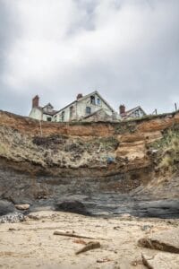
Forty odd years on some of the defences are still hanging in there just. It’s becoming a site of archaeology of memory, the change happening now, layers and surfaces being redrawn and relaid constantly. Happisburgh is a catalog of our failed attempts to stop a mass of water and increasingly unpredictable weather systems from eating away at the land. The sea has already beaten the infantry, the wood. Skeletons of the defences still stand in varying degrees of collapse, posts and cross beams; the backbone remains, the ribs of the snake have vanished in slow motion over the last forty years as funding for defending these outlying settlements on the East Coast has largely been withdrawn. In our lifetime it has changed in a huge way and this isn’t where it starts. The erosion of the coast is a fair constant, that dates back to the inundation of the old landscapes that sit out under the water in Doggerland, a place of mammoths and spear tips, flints and tree stumps lost to a Neolithic Tsunami and post glacial sea level rises. The softness of the materials here allows the water to do what it wants and has done for thousands of years. In recent times the road to the slipway has become a dead end hanging over a cliff. Beach Road terminates likewise. The cafe and guest houses are shadows of memories in the air above the beach and sea. All this past life is there hanging over this huge sandy cove cut into the soft glacial tills with the harder Wroxham Crag and the blue grey of the clays cropping up through the moving, shifting sands and pebble banks resisting and eroding more slowly.
 One of the things I like about Happisburgh is that despite our best attempts to stop nature doing what it does, we can’t. This dynamic is what makes the beaches along the East Coast unpredictable and interesting surfaces to watch and walk. The winter usually strips the skin back, the geology and archaeology becomes more obvious, the layers more noticeable and the passage of time and it’s processes more directly accessible to the onlooker wanting to see below the surface. Sometimes it goes out of balance. ‘Queen Cnut’, Bryony Nierop-Reading‘s house used to cling to the edge here along with the cafe and row of Edwardian Villas, We have photos of us with our children drinking tea and cake in the cafe garden, the washroom inside had a knitted toilet roll cover. The giant Scandinavian stones shipped across to protect the point below seem to have enervated parts of the beach; triggering a different set of tidal patterns of erosion and deposition of the mass of sand, this is the presumed purpose; for every reaction there’s an opposite and equal expression, a push one way and a shove another, sculpting surface in vain.
We walked from the nicely managed and tidy little car park through the field and down the frail clay slope, walking backwards through time. Turned left into the now constricted alley between the new line of rock armour and the point of the crumbling cliff edge. The layers have been recently cleaned by the weather, you can count down through time with your eyes, in places the varve clay marks the years of flood and dry in millimetres.
The sand has shifted again. Towards the old slipway base, now canted over and gradually losing its identity being absorbed in the line of the rock armour, and further up towards the familiar waypoint of the upside down pillbox which slipped off the cliff years ago is again up to its shoulders in sand. This end the beach feels like it has been at a consistently higher level ever since the work on moving the blocks around was completed a few months ago. And the other result of this seems to be that the sand in the bay to the South feels like it is lower than it has been for some time.
On the North beach you are under the glaciers and over the surface that hides some of the clay layers from the estuary of the Bytham River. Your feet are just above the spectre of the washed-out remains of our distant long-dead cousin’s footprints, locked into the hardening silts and muds protected by a blanket of later glacial clay deposits until the sea brushed them away. Any layers that remain are reburied under five feet of sand. Here the concrete rectangular pedestals all that remains of the metal stairway; in the early 21st century until 2011 this was how you got onto the beach. By 2012 the walkway was detached and laying in a field on the clifftop. The distance suddenly too great between the stairs and the cliff. As I look at photographs from a stark reminder of the slow power of the sea. Now they are isolated so far from the cliff that it doesn’t seem possible that there was ever a walkway to it. We carried on up past the pillbox to where the defences are just posts and cross members. The sea here chews at the cliff base undercutting the materials, occasionally revealing animal remains from our deep history, bits of thigh or a tooth, hippos, bears, mice and shells.
The South beach is more friendly. Wider and less pressing, open to the sky. It’s where people go and walk their dogs and meet up with flasks to stroll and chat hunkered down against the winter easterlies should there be one or amble in the unseasonal warmth as was the case. In the summer this is the beach where you go and sit and sunbathe or risk a swim in the pole spiked sea. It is a massive bite out of the coast; a bay that has formed over the last 20 years between the concrete defences that hold the sea back just North of Cart Gap and the rock armour and remains of the wooden piles and metal posts that protect the area North of the point before the coast dips down to the low areas at Walcott.
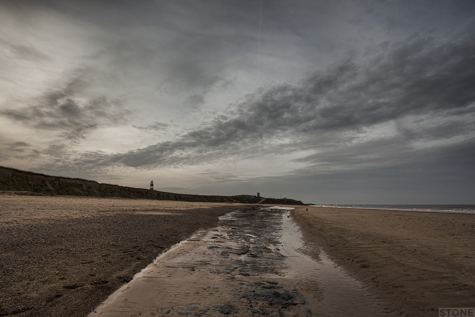
The cliffs here are lower, of a height where you can scramble up in places, just over the top are three pillboxes which form part of a network along this stretch of low cliff, behind them another marker of safety and protection, the vaguely talismanic stick of striped rock that is Happisburgh lighthouse. It is visible for miles inland, the flash across the horizon clearly visible miles inland on a dark night away from the sodium glow of North Walsham. The powerful lamps and lenses can throw its signature triple flash seventeen miles out across the sea warning seafarers of the perils of the ‘Haisboro sands’.
The beach has projections of clay and crag all of which are washed and eroding more or less slowly than the tills. It depends on the tides and on that blanket of sand that protects things. If you are lucky it will pull away the tablecloth and magically reveal the surface to you. It was along here in the outcrops of the ancient river sediments that form the Bytham clay which are occasionally visible at low tide that the now famous Palaeolithic hand axe was found in 2,000 by Mike Chambers, a find that focussed the searchlights of Archaeologists firmly onto Happisburgh from that moment onward. Sometimes the ribbed tops of this layer of clay can be seen in the curved run off channels the seawater carves.
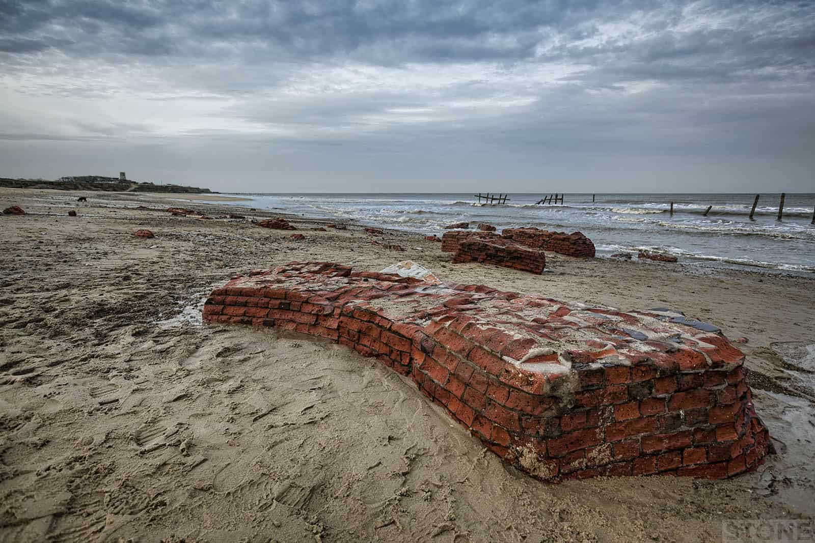
Amidst the sand and flint pebbles, when the tide has scoured out the bay you can also see the remains of something else. At the far end of the bay, just before where the concrete starts occasionally you can see a brick or two. This isn’t uncommon along the east coast, whole villages have crumbled and been inundated here Whimpwell lay to the South East of Happisburgh and is now lost out here, divers have found what could be a harbour wall on the sea bed just off the coast. What makes these bricks different is they are part of a second lighthouse, which previously stood on the low cliff edge but is now firmly on the beach in shattered fragments. When the waves have sucked the sand away and lowered the surface you can actually get a particular sense of the strong curve of the base. The bricks are eroding, sandblasted by waterborne particles, dissolving into sediments.
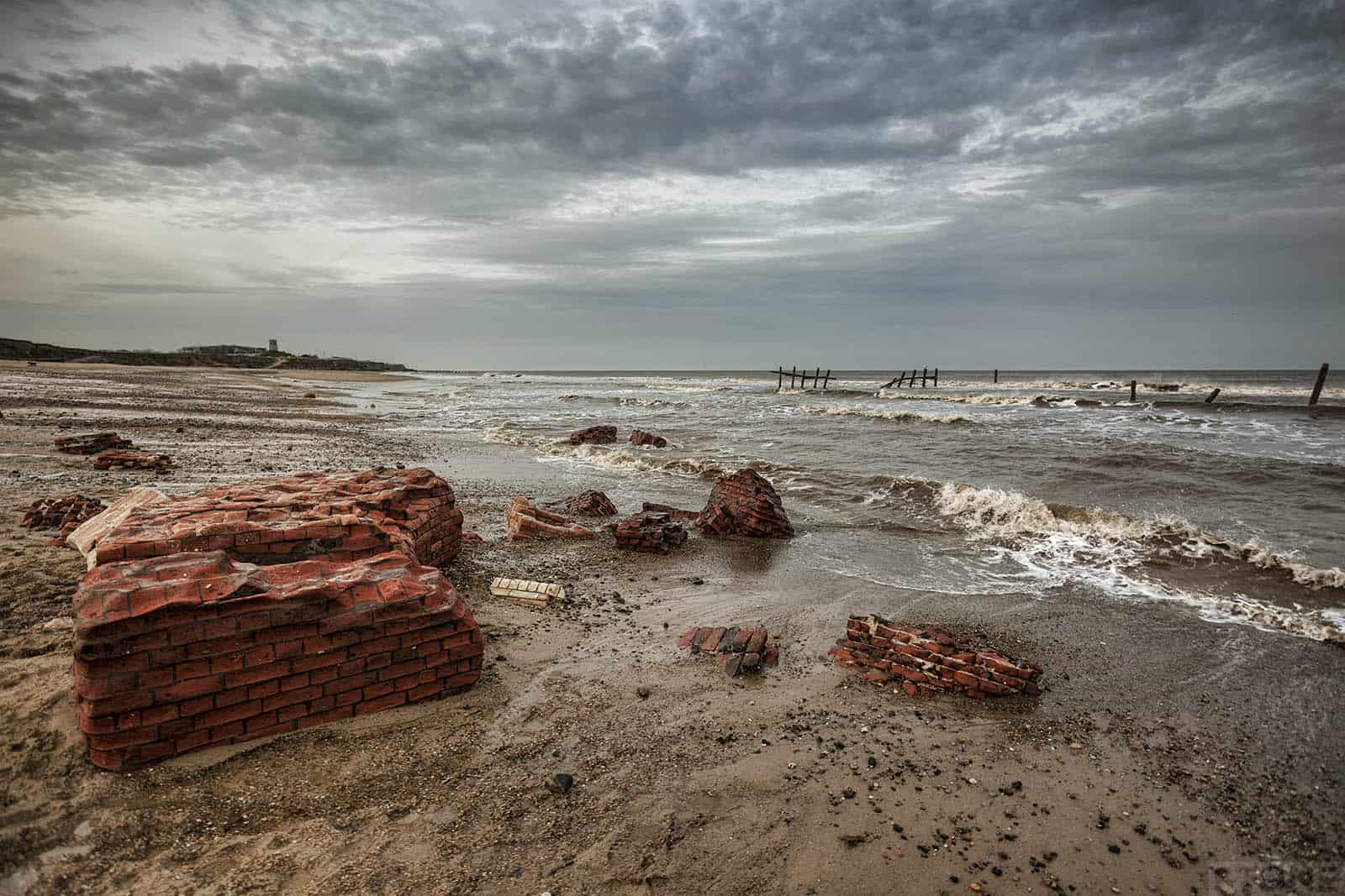
 Both lighthouses were built at the end of the eighteenth century in response to a large number of deaths at sea during the winter storms of 1789, it is alleged that as many as 70 ships and 600 men perished in the foul weather on the sandbanks in the stretch of water between Winterton Light and Cromer. Both where designed by William Wilkins and erected simultaneously in 1791. Low light was 20ft below Highlight. Originally they were both powered by candle, with an upgrade to oil and then coal gas. It became evident that the Low lighthouse was in peril from erosion and it was decommissioned in May 1883. The tower was demolished a month later except for the lantern and lamp housing which is still in use at Southwold. The foundations were left in situ.
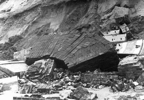 There are as far as I can ascertain no images of the lighthouse anywhere obvious, so that may require some further digging, It would be nice to see what it was like, it is unlikely that it had the red and white rock candy banding of it’s sister, that was put in place to identify it from the sea to avoid confusion with Winterton just after the Low light was decommissioned, we can I think assume they were of a similar design, and looking at most of Wilkins’ lighthouses they do follow a fairly distinct pattern. What is interesting is the photographic record we have is the relative position of the foundations particularly in relation to the cliffs at various fixed points in time. It is a narrow window into a process which shows very clearly how much land is being lost to the waves. In 1956 the base was still embedded in the cliff, by 1980 it had slipped and was naked to the air. Now it is at the water’s edge on a low tide, time grinding down and drawing a veil over the remains.
The glacier knocks in the cupboard, the desert sighs in the bed, and the crack in the tea-cup opens a lane to the land of the dead.
Photos and content © Nick Stone. Archive photos 1956 and 1980 © Norfolk County Council Heritage Explorer.
Thanks for that filled in lot’s of gaps in my knowledge of Happisburgh
I’ve only been going there for thirty years and oh what changes