
I’ve realised recently I rarely write about the city itself, or at least I don’t on here. This is actually based on something I wrote for something that was a sort of outline history of St Giles in relation to a couple of properties. I found it recently while rooting about and it seems a bit daft not to put it up. Typically when I wrote it I walked the street a few times. It’s an odd one mainly due to the height of the buildings which make it feel quite canyon-like with that sliver of sky above the road.
St Giles Street is one of the City of Norwich’s oldest medieval streets, ‘oldest’ not to be confused with the actual old bits like Fye Bridge and Conesford/King Street. It forms part of the original post-Anglo-Saxon and Anglo-Danish Medieval street plan of the city which grew up around the Norman Castle and Cathedral; a section of the French borough which grew in the late 11th century. The area was probably settled before in some form and the road may have existed as an exit out towards the periphery Anglian villages. St Giles sits at the head of a trading route from the Brecks in the south west of the county through the village of Earlham on into the Medieval City, running right down to the former Medieval civic centre at the Guildhall and the Norman Market place, still one of the largest open-air markets in Europe, I’ll pen something at length eventually about how that has changed, with maps because we all like maps and plans…
Originally the street was known as Nether Newport Street, with Bethel Street being Upper Newport Street, lined with stalls flowing up from the market place below. During the medieval period Norwich was one of the largest cities in Britain, a trading centre built up on the value of wool as a commodity and the associated trades, a busy port on the river and strong trading links to Europe.
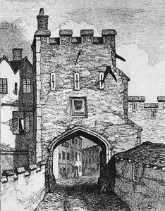
St Giles Gate, viewed from the outside by Henry Ninham, who lived nearby. The etching was taken from John Kirkpatrick’s depiction of the gate in 1720, which was copied Ninham in 1864.
By 1349 the city wall was completed including 12 gates. While these proved ineffective against attack, they were useful for levying taxes on the busy trading routes, increasing the wealth of the city more. St Giles Gate stood facing Earlham Road and the site which would eventually become the Roman Catholic Cathedral. St Giles was the Patron Saint of Lepers. As with many of the gates a Leper hospital stood just outside. Nothing remains of either the gate or the Leper Hospital. The gate was demolished in the late eighteenth century as industrialisation took hold and the requirement of being able to actually get in and out of the city made the already defunct and aging gates an impediment. The site is marked with a plaque on a nearby wall. Remains of the walls and towers can still be found nearby on Grapes Hill and Chapelfield, a corner tower is marked in flint on the roundabout.
The Street was originally divided into three sections, St Giles Broad Street at the bottom, St Giles Street itself and Upper St Giles Street near the old gate. The street was renamed as St Giles Street at the end of the nineteenth century with most properties then renumbered. As recently as 1882 the street was still paved with wood, it also hosted trams in the early decades of the 20th century.
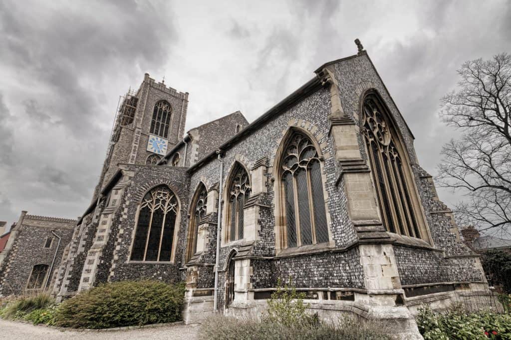
St Giles Church stands as testament to the prosperity of the area. Mentioned in the Domesday book, it is placed in what was originally part of the old French Borough. It has the tallest tower of any church in the city and sits on the highest ground. The church contains a carved Angel Roof and fine Victorian stained-glass windows created by Clayton and Bell of London and J Bell of Bristol. You will also see many memorials commemorating the doctors and surgeons who lived and worked in the St Giles Street area or in the Norfolk and Norwich Hospital nearby, an area which was at one time known as the Harley Street of Norwich.

The Grand Opera House, which became the Hippodrome (where St Giles car park now stands). The photo probably dates from around 1910. The building was demolished in the 1960s. Photo: Picture Norfolk.
St Giles contains many architectural and historical sites. Probably the most prominent was The Grand Opera House, latterly the Hippodrome Theatre, which stood where the Multi-storey car park is now sited. It hosted everything from opera and music hall to films and variety, including Laurel and Hardy, Charlie Chaplin, Gracie Fields, The Goons and Morecambe and Wise, among many others. It was damaged during the Baedeker Blitz on Norwich, repaired, then finally demolished in the 1960s. The grandeur of the street is retained in the facades of many of the frontages in the street, but is particularly evident in the Norwich Masonic Hall. Originally built in the late seventeenth century, it was adapted in the early 20th century by Albert Havers and is now a conference centre. At the lower end of the road you can also see a fine examples of the architecture of George Skipper, Telephone House which dwarves the street plus the local newspaper offices near the foot of the road, now a shop.
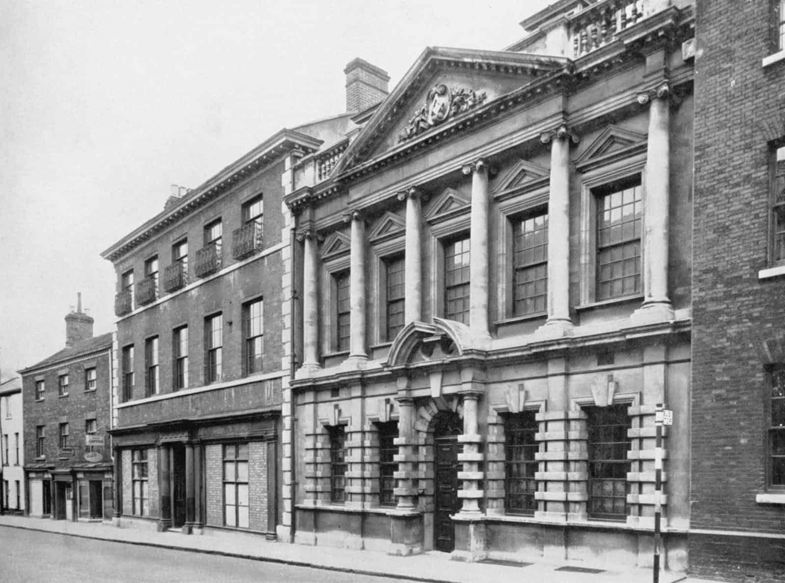
The Masonic Hall, originally built in the late seventeenth century, retains many of its features. – Picture Norfolk
There are so many buildings of note in the street, from the Salvation Army Citadel to the old YMCA building, each of which seems to have a deep history of occupants and trades it is almost impossible to cover them all in one blog so I won’t. However it is worth mentioning Churchman house in the brief context of the medical leanings of the street. In 1919 the corporation purchased the then fairly dilapidated Churchman House (now addressed as Bethel Street, although originally St Giles), dating from the 1730s, with it’s fine old plinths and bays, quoins and stucco plasterwork, It was previously home to Sir Thomas Churchman and his family, an alderman and Mayor. Under ownership of the city it became the medical offices for the area. It wasn’t until fairly recent times so many of us citizens entrances, joinings and exits have been recorded and/or celebrated there.
Many of the occupants of the area were from a medical background. With buildings used both as homes and surgeries and also working at the nearby hospitals. Peter Eade, himself a Fellow of the Royal College of Physicians, later mayor of the city, wrote a book on the Parish which is as good a source of detail as one would expect of a man with his exacting eye and physical verve; the list of doctors he compiled in the street over two centuries is actually mind-boggling. Eade was also later Mayor and lived in St Giles. He was responsible for the regeneration and later planting schemes in Chapelfield Gardens and in the 1890s helped the Friends of Norwich Museums secure the castle, mound and complex as a museum for the city. He is remembered in Eade Road in the Victorian suburbs of the city just off Aylsham Road.
One of the most famous occupants of St Giles was during the early to mid-1800s. Henry Woodcock was a well-known and respected Dentist and Surgeon, who later rose to eminence through the civic ranks to become the Sheriff of Norwich in 1838 and the Mayor of the city for two terms between 1849 and 1851. He is remembered as a political Liberal, ‘affable and genial and of great hospitality’. He gifted the clock tower on the City Guildhall at the bottom of St Giles to the city in 1850. At the base of the clock is an inscription, Henry Woodcock, Mayor and Sola Virtus Invicta ‘Virtue alone cannot be conquered’, the motto of the Dukes of Norfolk. He is also remembered in the names of the streets on the Mile Cross Estate. witha kbab shop at his foot and another at his head.
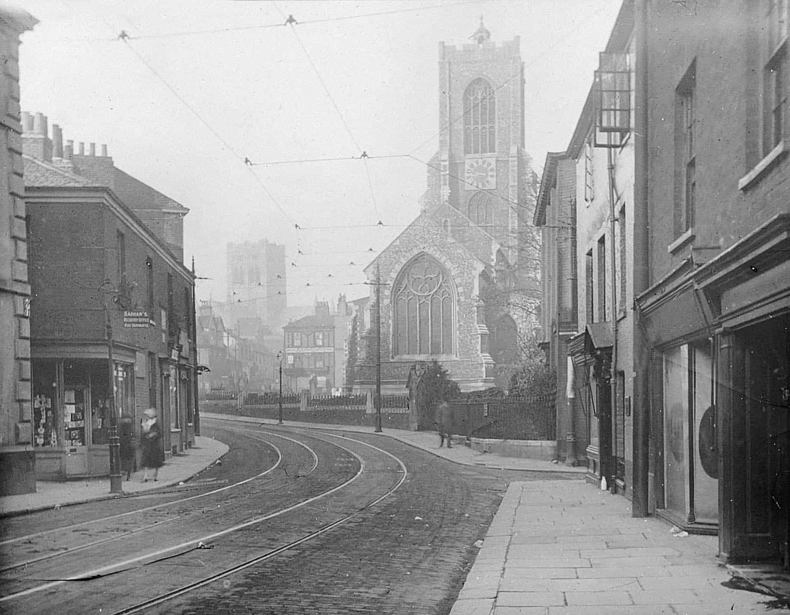
St Giles Church viewed from the top of St Giles Street, Upper St Giles Street is visible in front of the tower of the newly built St John the baptist Roman Catholic Cathedral in the distance. Photo: Picture Norfolk.
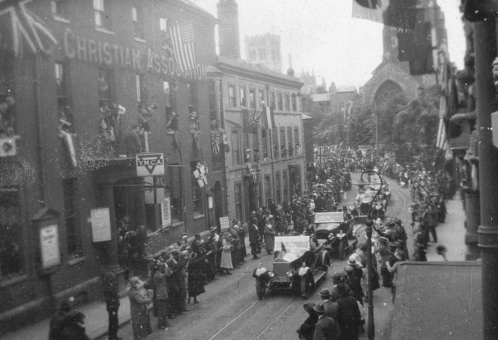
Royalty visits the city in the 1920s. The royal procession moves down St Giles to meet dignitaries in the civic buildings at the foot of the street. Photo: Picture Norfolk.
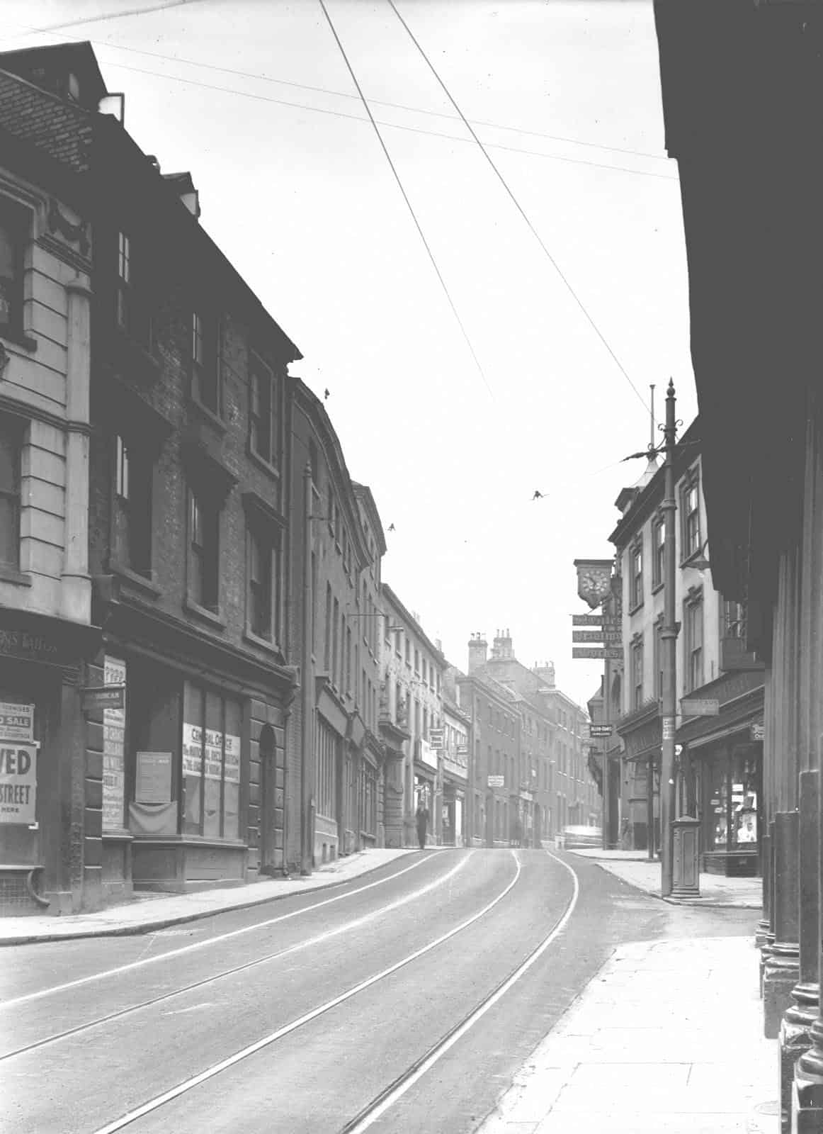
St Giles Street, looking west from the city in 1935. The photo was taken by George Swain who had two studios with his wife Mildred, one in Davey Place and one at 27 St Giles Street, Norwich.
Photo: Picture Norfolk.
There is a crypt in the basement of St Giles House. Is it still there and if so what is it used for?
The brick undercroft under St Giles House dates from the 15th century and may once have been part of the God’s House hospital site which was rebuilt in 1446-1472. According to the English Heritage listing details there are the remains of 2 ½-bays of the undercroft with double order ribs. A survey of 1979 noted a section of vaulted undercroft beneath the late 19th century block. The transverse rib respond, with part of the arch profile, exists on the west wall. It is positioned at right-angles to the street line.
When I visited it I saw a section of rib vaulted undercroft which terminated in a modern brick wall. It has been patched up with wood and metal supports and is used for storage. It is reached from inside the building via a passageway from a modern cellar. It is not open to the public.
Fascinating. I lived in a bedsit on the top floor of 51 St Giles (the building on the extreme right in the first photo on this webpage) from the autumn of 1976 to the spring of 1977. I was working at Norwich Union and it was my gap year before going to university. It really didn’t look much different from these pictures, apart from the disappearance of the tram rails and the overhead cables, and indeed it still doesn’t. These was a secondhand record shop across the road from me, but further down, called Ives, owned by an older couple. I was faintly amazed when I went to university and met my wife (to whom I have been married since 1981) to discover that Mrs Ives was her godmother and had grown up with her mother in Yorkshire.
Fascinating indeed Guy. I bought 51 St Giles Street in 2006, after acquiring the lease of the framing and exhibition centre on the ground floor in 2002.
I converted the house into flats. Your bedsit on the top floor is now either part of a one bedroom or two bedroom flat, depending whereabouts in the house it was.
That is equally interesting David. My room was the one at upper right as looking from the street. I do not remember much about the interior except that there was at least one other bedsit on the top floor. There was an electric bar fire and one ceiling light. No running water or cooking facilities in the room. We had to use a kitchen and a bathroom which was at the back of the house and I do remember that was slightly down the stairs. The house belonged to a Mr and Mrs Dodhi who charged me 8 pounds a week for my room. They lived on the 1st floor but had to sell up at Easter 1977. They planned to take their tenants with them but in the event could not. I had to move out and lived in some dive off the Earlham Rd until the summer of 1977 when I left Norwich and went to university. Writing this in 2023 as a 66-year-old grandfather it’s funny to think of living in St Giles aged 19 because the street looks so similar today yet my life has changed beyond recognition. I should like to look inside again one day, so perhaps I’ll call in if I am passing (but I live in Lincolnshire now).
I visited st Giles hotel visiting Norwich for the day from suffolkafternoon tea I passed Gladstone house noticed sign on front of building ..very interesting building and history
I lived in the YMCA for about 6 months in ( roughly ) 1972. It did the job as rented places were few and far between.
My future wife stayed in the YWCA opposite and we walked to City Hall to get married.
We had to get married as our lovely landlord wouldn’t let to people living in sin.
Funnily enough our marriage didn’t last.
Thank god some things have changed for the better .